We have now passed what is traditionally known as the "spring (northern hemisphere) predictability barrier" when it comes to ENSO predictions.
The period between March and May carries considerable uncertainty but as we pass this period models become more reliable in their forecasts. This is why the latest update (issued July 9) from the NOAA Climate Prediction Center had this to say about where we are:
There is an 81% chance of a very strong El Niño during October-December that would rank among the largest El Niño events in the historical record going back to 1950. Even the strongest El Niño events do not lead to the typical impact everywhere, but stronger events can more significantly tilt the odds in favor of expected outcomes
Zeke Hausfather has done some really great work in taking 14 models, including NOAA's and creating a synthesis which puts everything together from the major climate monitoring services. Here is the latest graphic from that work:

Based on all the models, we now know with considerable certainty that the El Niño is underway and there is a very high probability of it being a record breaking event.
What should we in South Africa and the Garden Route look out for?
The El Niño on its own does not determine what impacts will be felt in Southern Africa, the Western Cape and Garden Route. Impacts are determined by how the other systems that affect our climate and weather patterns interact with the El Niño event.
The two major systems that we have to pay attention to are what is known as the Indian Ocean Dipole and the Southern Annular Mode. These two systems could either reinforce the El Niño event or help temper its impacts in this region.
The Indian Ocean Dipole (IOD)
The IOD is a climate pattern involving an irregular oscillation of sea-surface temperatures in the tropical Indian Ocean. It is often referred to as El Niño's "cousin" because it operates on a similar ocean-atmosphere feedback loop, just over a smaller body of water.
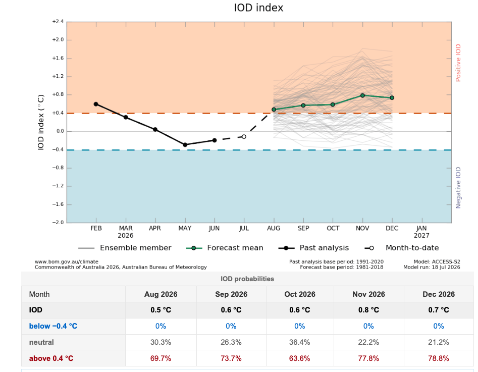
When water temperatures are warmer than average in the western Indian Ocean (near Africa) and cooler in the east (near Indonesia) this is described as a Positive IOD. This brings heavy rainfall and flooding to East Africa and much drier conditions to Southern Africa. When this system is positive it tends to reinforce the El Niño over Southern Africa.
Currently the latest forecast has the IOD as positive until at least December 2026
So we now have a forecast for a very strong El Niño and a positive IOD. What about the Southern Annular Mode (SAM)?
The Souther Annular Mode (SAM)
Here is a great explanation of what the SAM is from the Australian Bureau of Meteorology.
So to sum up, in the southern hemisphere, a positive SAM shifts cold fronts, and thus rainfall further south. A negative SAM shifts cold fronts further north, bringing a greater chance of rainfall.
Did you notice the explanation of what the impact of an El Niño is on the SAM? During an El Niño event the SAM tends negative, which in theory results in a greater chance of rainfall for the Western Cape. However, in recent years research has shown that, due to the heating planet, the SAM has trended positive. This means that an El Niño event could simply move the SAM to a neutral state instead of forcing it negative.
Here is the current SAM forecast taking us out to August 25th.

As can be seen from the above, the SAM is currently negative which should make it easier for cold fronts to reach the Western Cape resulting in dam and river recharge opportunities. Rainfall events can also occur in the neutral state.
In its current negative and then neutral state there is little reinforcement of the strengthening El Niño at present.
Summing it all up
Compared with where we were a month ago, the positive IOD forecast has become a more significant piece of evidence that the tropical climate system is beginning to align in a way that can reinforce the exceptionally strong El Niño. At the same time, the SAM forecast is not currently adding to that risk, and in the short term may even allow more typical frontal activity than would occur under a persistently positive SAM.
For Southern Africa, that means the risk outlook is elevated but not locked in. If, over the next 6–10 weeks, the SAM were to trend and remain predominantly positive while the IOD verifies as positive and El Niño continues on its projected trajectory, then the large-scale circulation would be much closer to the classic setup associated with severe regional drought. That is why, after monitoring the evolution of El Niño itself, the SAM becomes the single most important indicator to watch from August into October, while the IOD provides the broader seasonal background.