A new Seasonal Climate Watch released by the South African Weather Service (SAWS) offers an important and sobering piece of context for Garden Route’s current water stress.
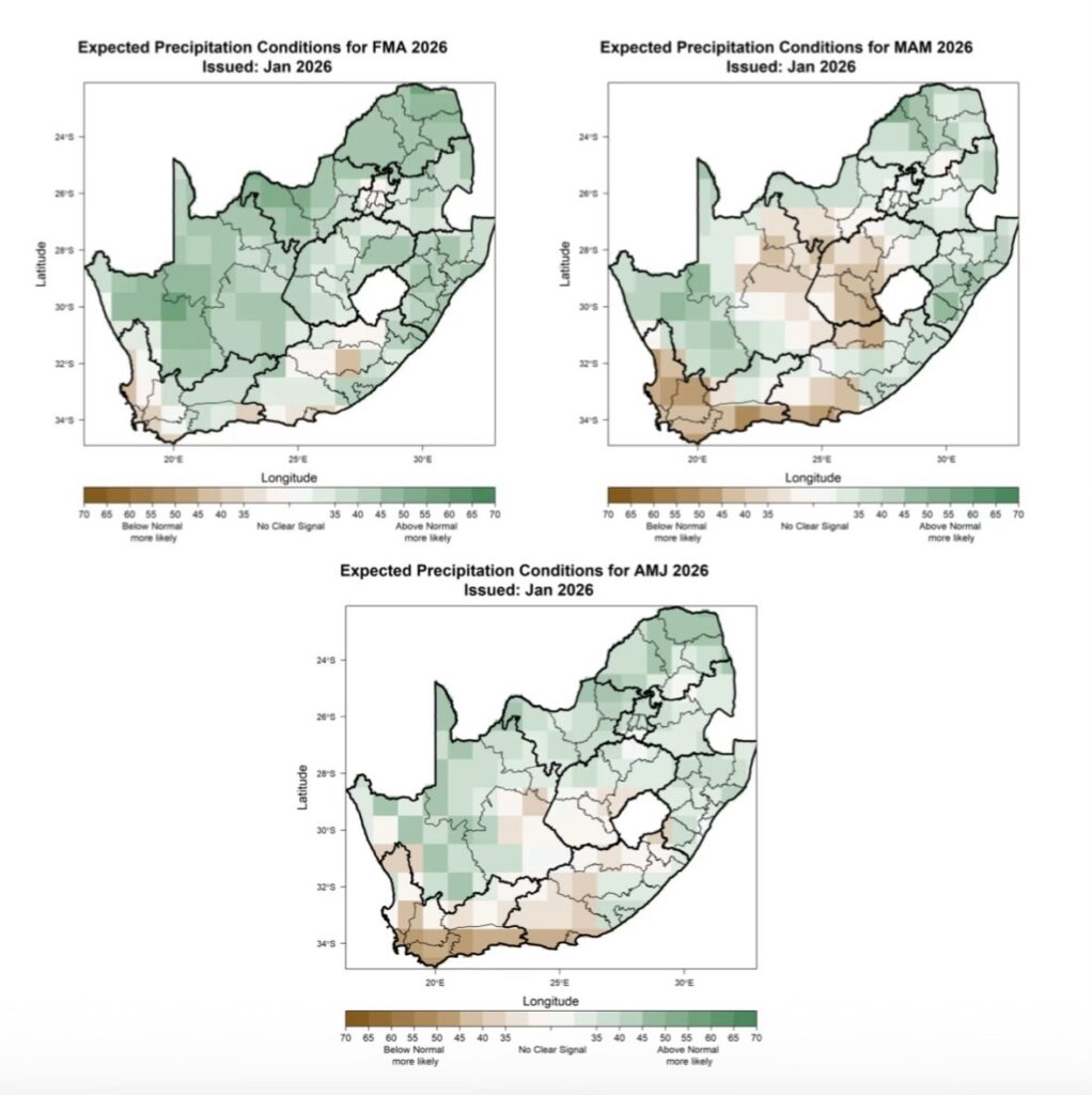
The short version: there is no clear signal of relief in the months ahead.
What the climate outlook is saying
According to SAWS, much of the southern Cape is expected to experience persistently below-normal rainfall through late summer and into early autumn. While isolated rain events may still occur, there is no strong indication of sustained or widespread rainfall that would meaningfully restore river flows or refill dams in the near term.
This matters, because in Knysna’s example, the water system is not failing due to one dry week or one missed storm. It is under strain because water supply margins are thin, river flows are already near critical thresholds, and storage is is having to be carefully protected to buy time.
In this context, occasional showers help but they do not reset the system and the projection is that this will not happen soon.
Why “average rain” is no longer enough
January provides a useful example. Sticking with Knysna, the town and surrounds recorded roughly its historical average rainfall for the month, yet the Knysna river’s flow remained weak and the system has stayed under high stress. This highlights a critical shift many communities on the Garden Route are now facing:
what used to be “normal” rainfall no longer guarantees water security.
Forecast higher temperatures during the forecast period will increase evaporation, dry soils will absorb more of the first rains, and the catchments will respond more slowly as a result.
The consequence of this is that rain will increasingly fail to translate into reliable runoff especially when precedding dry, hot periods.
What this means for the months ahead
Taken together, the SAWS outlook and current system behaviour points to a clear conclusion:
The region cannot plan on rain to rescue the system in the short term. That is why municipalities should focus their strategies on:
- maximising non-storage sources (rivers, springs, boreholes etc.)
- protecting storage dams as a strategic reserves, and
- pushing hard for consumption reduction.
This reason of course is that the rain that does fall will not necessarily reset water systems.
Why early warning matters
In a climate, like the one we are moving into a system can appear stable one day and tip quickly the next when river flows fall, pumps fail, or consumption spikes.
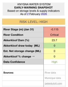
That is why early-warning indicators, like river stage measurements, storage trends, and net gains or losses matter so much. They tell us whether a plan is holding before a crisis becomes unavoidable.
Below is an example of an early-warning system for Knysna.
The takeaway
The Garden Route’s water challenges are now about learning to manage through longer dry spells.
The climate outlook is obviously not a reason to panic but it is a reason for a healthy dose of realism and some serious action on adaptation.
It’s very clear from this latest SAWS outlook that in the months ahead, how we use water will matter more than how much rain falls when it does.