Reading time: 5 minutes
The Headline
Confidence is increasing that the global climate system is aligning toward a significant El Niño event, with multiple independent forecasting centres now converging on a similar outlook.
While uncertainty remains around the magnitude of regional impacts, the level of agreement between observations, forecast models and official agencies is notably stronger than it was a month ago. For Southern Africa, this represents an increasingly important shift in the seasonal risk outlook.
Executive Summary
July marked another step in the maturation of the developing El Niño. Ocean temperatures across the central and eastern equatorial Pacific continued to warm significantly, atmospheric circulation remained consistent with a coupled El Niño, and major forecasting centres strengthened their confidence that the event will continue to intensify through the second half of 2026.
At the same time, forecasts increasingly favour the development of a positive Indian Ocean Dipole during spring, a pattern that has historically reinforced El Niño’s influence over parts of Southern Africa. The current Southern Annular Mode forecast, however, shows near neutral in the coming weeks following a recent negative phase, suggesting that one important atmospheric driver is not presently amplifying drying conditions over the southern Cape.
The result is a climate system in which the large-scale drivers are becoming progressively more aligned, increasing confidence in the seasonal outlook while still leaving uncertainty in regional rainfall outcomes.
Climate Driver Assessment
| Driver | Current Status | Trend | Confidence |
|---|---|---|---|
| ENSO | 🔴 El Niño established | ▲ Strengthening | High |
| Indian Ocean Dipole | 🟠 Postive phase favoured | ▲ Increasing | Moderate-High |
| Southern Annular Mode | 🟡 Near Neutral | ► Stable | Moderate |
| Overal Climate Signal | Increasing alignment | ▲ Increasing | High |
What changed during July
1. Confidence increased
The most significant development during July was the growing agreement between independent forecasting systems.
NOAA continues to identify a strengthening El Niño with oceanic and atmospheric conditions fully consistent with the event. The agency assigns a 97% probability that El Niño will persist through early 2027 and an 81% probability that it will reach very strong intensity during October–December.
The IRI multi-model ensemble similarly projects continued strengthening through late 2026, while the ECMWF seasonal ensemble also favours a strong to very strong event.


This convergence between observations and forecasts substantially increases confidence in the broad evolution of the climate system.
2. The atmosphere is now responding
One of the defining characteristics of El Niño is the coupling between ocean and atmosphere.
During July:
- enhanced convection persisted over the central Pacific,
- suppressed convection continued over Indonesia,
- low-level westerly wind anomalies remained established,
- upper-ocean heat content stayed well above average.
These are indicators that the event is now a fully coupled climate phenomenon.
3. The Indian Ocean is becoming increasingly important
Forecast guidance now consistently favours a positive Indian Ocean Dipole developing during spring, with probabilities generally around 70–80% by late 2026.

While the IOD remains neutral at present, its expected evolution increases the likelihood that it will reinforce the broader El Niño circulation pattern during the coming months.
Southern Africa Outlook
For Southern Africa, the seasonal outlook should be viewed as an evolving probability rather than a fixed forecast.
The South African Weather Service notes that El Niño has entered a weak phase but is expected to strengthen rapidly toward a strong event during the coming months. It also highlights that late winter and spring are expected to be drier than normal across the south-western and southern coastal regions, while much of the country is favoured to experience above-normal temperatures.
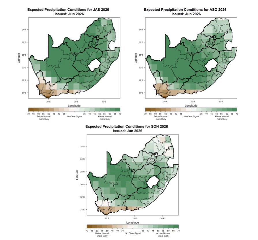
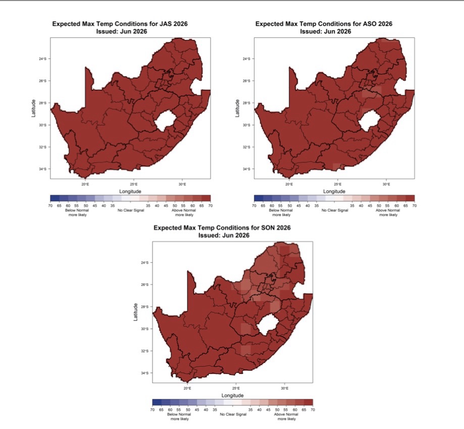
Importantly, this does not imply that every rainfall event will be suppressed or that drought conditions are inevitable. Remember that seasonal climate drivers show the general direction of travel but they don’t determine individual weather systems outcomes.
Garden Route Watch
The Garden Route remains in its winter recharge season, making rainfall during the coming weeks particularly important.
Although the broader climate background is becoming less favourable for rainfall later in the year, current guidance indicates that the Southern Annular Mode is likely to remain near neutral after its recent negative phase. This suggests opportunities for frontal systems to continue affecting the region before the stronger influence of the tropical climate drivers emerges during spring and early summer.
For water managers and communities the remainder of winter therefore represents an important window for catchment recharge and water conservation in general.
Confidence Assessment
Confidence in the overall climate outlook has increased since June.
This assessment is based on the convergence of multiple independent sources:
- NOAA observations and outlooks,
- ECMWF seasonal forecasts,
- IRI multi-model guidance,
- WMO global seasonal assessment,
- ACCESS-S2 forecasts for the Southern Hemisphere,
- South African Weather Service regional outlook.
While regional outcomes remain uncertain, the consistency across the above sources provides greater confidence in the direction of large-scale climate change over the coming months.
Looking Ahead
Key indicators to watch during August include:
- Whether El Niño continues strengthening at the forecast rate.
- Confirmation that a positive Indian Ocean Dipole becomes a reality.
- Evolution of the Southern Annular Mode during the remainder of winter.
- Early signs that Southern Hemisphere circulation is responding to the increasingly coupled tropical climate system.
July Assessment Summary
The July evidence suggests that the climate conversation has entered a new phase. The important question now is how the combination of El Niño, the Indian Ocean Dipole and Southern Hemisphere circulation will shape regional climate risk during the next 6-18 months.
What can you to do prepare
- Develop a personal early-waring system
- Become fire-ready
- Here is a general checklist